


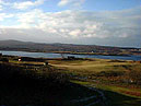
Bernisdale Area
Know something else about this area?
Contact ISBuC today by phone on (01470) 552223
or email info@isbuc.co.uk and tell us about it.
'East of Eyre'
Know something else about this area?
Contact ISBuC today by phone on (01470) 552223
or email info@isbuc.co.uk and tell us about it.
'East of Eyre'
Bernisdale Area Information
People
Saint Columba
Vikings on Skye
Sights
Standing Stones
Timelines
1500 - 1549


People
Saint Columba
Vikings on Skye
Sights
Standing Stones
Timelines
1500 - 1549
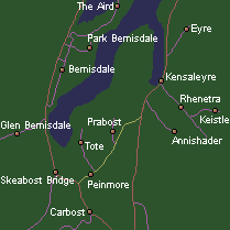
BERNISDALE (Norse: Bjorn's dale)
CARBOST (Norse: Kari's town)
EYRE (Gaelic: Gravel shore)
GLEN BERNISDALE
KEISTLE (Norse: Low land between water)
KENSALEYRE (Gaelic: Head of the gravel shore)
Kensaleyre stands near the end of a long tidal bay. Two standing stones near the shore are said to have been used as a cooking place by Fionn, a mythical hunter and warrior.
PARK BERNISDALE
PEINMORE (Gaelic: Big penny land)
PRABOST (Norse: Broad farm)
RHENETRA (Gaelic: Level shore)
SKEABOST BRIDGE (Norse: Protected land)
The 'Battle of Trouternes' or 'Battle of Achadh na Fala' (field of blood) between the MacDonalds and the MacLeods took place here in 1539 to decide who would own Trotternish. They fought on the banks of the Skeabost river, which at the time was the boundary of MacDonald and MacLeod land.
Saint Columba's Chapel (ruin and graveyard) is situated on a small island in the River Snizort and vies with 'Eilean a` Loch' near Kilmuir for being the first Christian church on the island.
THE AIRD (Gaelic: Point or headland)
TOTE (Gaelic: Ruin)
The site of a viking grave which was unearthed after the first World War. A number of Viking artefacts were found in the grave. By the side of the road, a short way from the junction stands Clach Ard, a standing stone covered in very weathered remains of Pictish carving.